Enhancing harvest mobile app usability
Accelerating feature design and validation for agricultural operations


Key Takeaways
John Deere needed to design and validate a new Dual Map Display feature for the Harvest Mobile App — enabling real-time side-by-side field data comparison under tight delivery constraints
OneSpring applied its JAM (Joint Application Modeling) methodology in a three-week engagement, aligning stakeholders and iterating from low-fidelity to validated medium-fidelity prototype
Results: 50% reduction in design-to-specification time, 75% faster feature validation, and a development-ready prototype with full documentation and demo videos
Background
John Deere, a global leader in agriculture and manufacturing, continues to evolve its digital solutions to support data-driven decision-making for modern farmers. One of its key innovations is the Harvest Mobile App, a tool designed to deliver real-time data and geospatial insights during field operations.
As farmers increasingly rely on precise and timely information to monitor yield, assess variety performance, and manage planting variability, the Harvest Mobile App plays a crucial role in linking live and historical data to active fieldwork.
Recognizing the growing demand for in-field comparisons, John Deere identified the need for a new Dual Map Display feature that would enable users to visually compare multiple data layers—such as seed variety, population, and yield—simultaneously.
This functionality empowers users to uncover patterns, identify contributing factors, and make more informed decisions during critical phases like planting and harvest.

John Deere single harvest prototype.
Challenge
Operators needed to simultaneously view and compare different map layers in real time. The feature also needed to be technically viable across existing platforms while ensuring intuitive usability.
Compare live and historical field attributes side-by-side to identify trends and insights
Enable real-time decision-making with minimal disruption to ongoing operations
Align product design with user needs, technical constraints, and brand standards
Additional requirements included preserving accessibility to live mapping functions, integrating background data layers (e.g., soil type, elevation), and ensuring compatibility with legacy systems such as 2630, SeedStar Mobile, and Field Analyzer. Preference for side-by-side visual comparison was confirmed through internal validation and competitive analysis of peer tools such as FieldView.
Solution
OneSpring applied its JAM (Joint Application Modeling) methodology to rapidly align stakeholders, generate design concepts, and validate user needs in a compressed three-week engagement.
In the first week, our multidisciplinary team was assembled, including business, IT, UX, and product stakeholders. The team reviewed existing functionality and pain points from previous systems and tools, including Apex and Field Analyzer. A competitive analysis helped establish design standards. Initial use case scenarios were created, and a low-fidelity prototype was developed in preparation for the upcoming collaborative workshop.
Next, OneSpring facilitated a two-day JAM Session, bringing together core stakeholders to align on design priorities and validate the initial prototype. Rapid iteration resulted in a medium-fidelity prototype focused on side-by-side map comparison, legend clarity, layer switching, and follow-me mode. Discussions addressed key constraints such as zoom synchronization, data source pairing (live/live or live/historical), and map attribute compatibility.
"The JAM Sessions and iterative design process streamlined our product innovation, cutting design time in half while delivering a highly usable, validated prototype."
– Director, Technology
By our final week, the prototype and functional documentation were finalized. User stories, acceptance criteria, annotated screens, and business rules were compiled for handoff. Demo videos were created to communicate the final design to stakeholders beyond the core team, improving buy-in and accelerating organizational awareness.
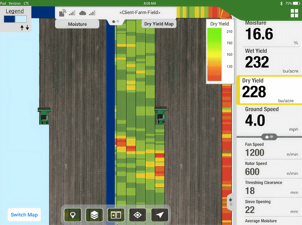
John Deere dual harvest prototype.
Results
The project yielded a functional prototype, validated across multiple user scenarios, that directly supports field operators in making real-time, data-informed decisions. The documentation also enabled faster engineering collaboration and reduced downstream development risk. The effort produced measurable outcomes in delivery speed, design quality, and stakeholder alignment.
50% reduction in design-to-specification time
75% faster validation of complex feature functionality
Seamless experience for comparing multiple data attributes in the field
Increased design clarity and development readiness
Cut Design Time
50%
Accelerated Validation
75%
Conclusion
By applying a collaborative UX approach, OneSpring helped John Deere successfully deliver a new feature that enhances the precision, usability, and overall utility of the Harvest Mobile App.
The Dual Map Display functionality empowers users with clearer insights into crop variability and performance by enabling real-time, side-by-side comparisons of live and historical field data.
The structured JAM process provided a focused and time-efficient framework for aligning decision-making and validating user needs.
Final deliverables included interactive prototypes, demonstration videos, and complete functional documentation to support seamless development.
This initiative reinforces John Deere’s leadership in precision farming, enabling smarter in-field decision-making through intuitive and data-rich visualizations.
Frequently Asked Questions
What is John Deere's Harvest Mobile App?
The Harvest Mobile App is John Deere's field operations tool that gives farmers real-time data and geospatial insights during harvest and planting. It links live sensor data and historical field records to active fieldwork, helping operators monitor yield, assess seed variety performance, and manage planting variability from the cab.
What was the Dual Map Display feature and why was it needed?
The Dual Map Display allows farmers to compare two map layers — like seed variety vs. yield, or population vs. elevation — side-by-side in real time. Operators needed this to identify patterns and contributing factors during critical field operations, rather than switching between maps sequentially and losing context.
What is OneSpring's JAM methodology and how did it work here?
JAM (Joint Application Modeling) is OneSpring's structured approach for rapidly aligning stakeholders, generating design concepts, and validating user needs in compressed engagements. For John Deere, it ran over three weeks: week one for team assembly, competitive analysis, and a low-fidelity prototype; week two for a two-day stakeholder workshop and medium-fidelity design; week three for final documentation and handoff.
What technical constraints shaped the Dual Map Display design?
The feature needed to work across existing platforms — including 2630, SeedStar Mobile, and Field Analyzer — while supporting zoom synchronization between maps, flexible data source pairing (live/live or live/historical), and compatibility with background layers like soil type and elevation. Competitive analysis of tools like FieldView also informed the side-by-side layout approach.
What results did the John Deere JAM engagement produce?
The three-week engagement delivered a 50% reduction in design-to-specification time compared to traditional design processes, 75% faster validation of complex feature functionality, and a fully development-ready prototype with user stories, acceptance criteria, annotated screens, business rules, and demo videos for stakeholder alignment.
Why are agile UX methods important for agricultural technology?
Agricultural technology products are tied to planting and harvest seasons — there's no flexibility to miss a release window. Agile UX methods like JAM allow teams to align quickly, validate designs under tight timelines, and deliver development-ready specs without sacrificing quality or user-centeredness.
How does precision agriculture data change what farmers need from mobile apps?
Modern precision agriculture generates enormous amounts of geospatial data — yield maps, soil analysis, variety performance, and more. Farmers need apps that make this data actionable in the field, not just viewable after the fact. The Dual Map Display directly addressed this by enabling real-time comparison so operators could make in-the-moment decisions during harvest.